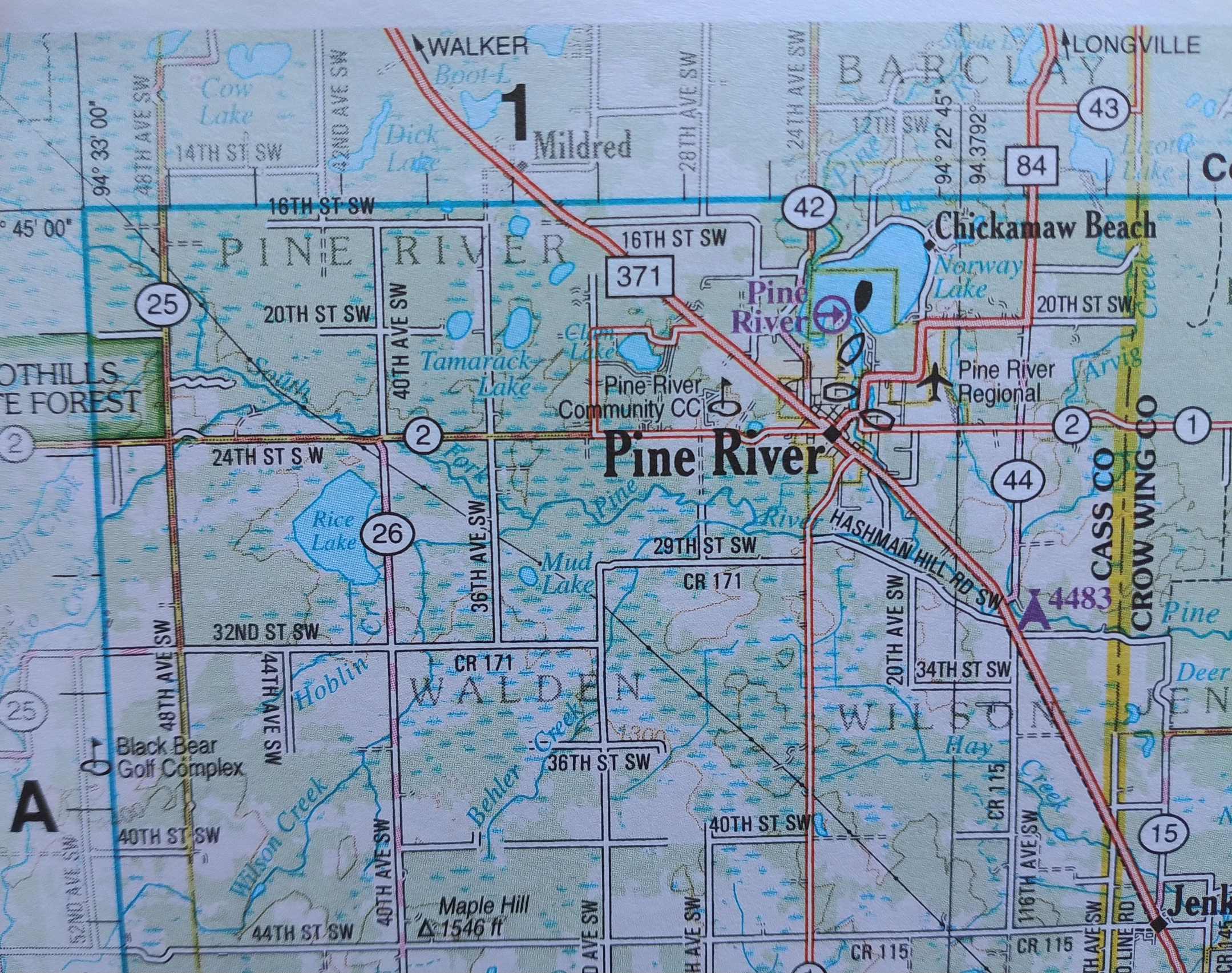
I FOLLOWED THE PRINTED directions as the phone squawked them aloud. We were about 15 miles west of Pine River, turning off County Road 2 (in whatever county) onto Minnesota State Highway 64.
My eyes moved down the paper, scanning for the next turn after three miles on the state highway. Take a left onto 12th St SW, Randy had written. He jotted the directions just for me because he knows I like the route mapped on paper.
“I hope it’s not gravel,” I said, noting the street, not county road, wordage
No sooner had the words popped from my mouth than the phone directed us left onto 12th Street. Randy steered off the highway. Onto gravel. Then the phone ceased barking. Our cell service had dropped.
Randy stopped the van after I protested. “I don’t want to drive on 7.3 miles of gravel.” I’d read ahead on the directions, noted the distance and noted the next two turns, onto Huntersville and Hubbard Roads. Probably more gravel.

“Let’s just look at a map and figure out where to go,” I said, reaching for the glove box. No map. Randy had failed to transfer maps from our old van into the new-to-us used van we bought earlier this summer. I asked about an atlas, which we sometimes carry with us. Nope, that would be in my office.
So there we were, in the middle of nowhere in an unfamiliar area of northern Minnesota. No cell service. No map. No atlas. No anything except understanding that we needed to head northwest to reach our destination, Jack Pines Resort a mile outside of Osage. By that time I was feeling stressed. I had a book launch party to reach by 1 pm. I can’t even tell you what time it was at that point, except time to get moving.
Randy swung the van around, got back onto the northbound state highway, then took the next westbound asphalt road. I thought we were back on track…until the road began to curve, then straighten, then curve. Mile after mile after mile for perhaps 20-plus miles. Speeds dropped, sometime as low as 25 mph. We were not making good time. I was not a happy wife. Or a happy writer.
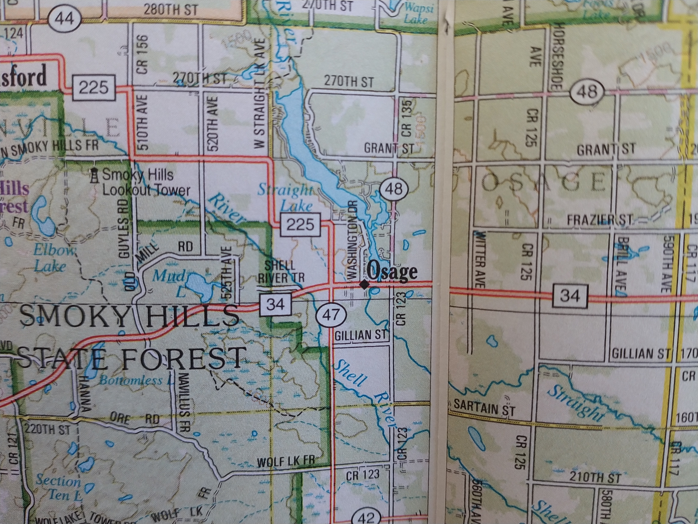
Eventually, spotty cell service returned, long enough to open my email and read directions to the resort sent by the book event organizer. I felt my body relax. We might make it on time. And we did. With 10 minutes to grab name tags, pee and settle onto comfy chairs in the back row.
So what did we learn? You cannot rely on cellphone directions, especially in a no-cell-coverage-middle-of-nowhere-location. Always write down directions. Check that the planned route does not include gravel. And carry a paper map in your glove box. Had we done all of those things, I would not have been a stressed wife who was mad at her husband. But at least I wasn’t a stressed writer worried about reading her work aloud at the book launch party. I was too distracted by the stress of being lost.
© Copyright 2024 Audrey Kletscher Helbling


Being lost, especially when you need to be somewhere on time, is so frustrating! Glad you arrived on time. We keep paper maps in our car too. You never know.
“You never know…” Exactly.
congrats on your book launch is it a new one you ahve written recently? Please share if so. Thanks kathy G Yes we do need the old map in the glove box too :):):):)
Kathy, my work is included in “Talking Stick 33, Earth Signs,” an anthology of works by Minnesota writers or those with a strong connection to the state. Here’s a blog post I published just days ago about this book: https://mnprairieroots.com/2024/09/19/latest-talking-stick-anthology-publishes-im-in-again/
I’m glad you made it to your literary event on time. Like you, I never travel without written directions and my maps. I have a best friend who lives near Park Rapids on the road to Osage, I often drive through Pine River to get over there. There are large sections on that route where there is no cell service. If ever you need a chauffeur going that direction, let me know. There’s an Art Leap event happening in Park Rapids the last weekend of this month I plan to go to with my friend. We went a few years ago and it was so fun. Creative people are everywhere!
Thank you, Rose. That Art Leap sounds like fun. We have a similar one here in the Faribault area. I need to go again; it’s been a few years.
There’s nothing worse than getting lost when you’re almost there. So glad you could navigate your way to the destination and had a good time at your book reading and I’m sure when you get home those maps will be back in the vehicle!!!!! 🧭🚙😵💫🚗😩 Roxy
You’re right on that, Roxy. Maps from Minnesota, Wisconsin and Iowa are now in the glove box of the “new” van.
so glad you made it in time, but is sure is so very frustrating when that happens. I sometimes write myself notes about how to get to a destination, as I have an incredibly bad sense of direction, and I need back up for the gps, just in case. even if I had a paper map it would be challenging for me.
Beth, I am directionally challenged also. Except when I’m on the straight grid of the prairie.
that makes perfect sense –
Cell Phone service, GPS, old maps, and laughing out loud. My wife was “directionally” challenged – while me? Not so much. I know of several black out areas where cell phone service – even radio service – are not available or do not work. GPS generated directions has generated a new term called “Death by GPS” which was coined after a driver tried using GPS to save time but which cost them their life using an unfamiliar unpaved road. In one case, my familiarity with “country” roads saved me, not because I was familiar with the road but rather recognized it for what it was. I was riding along doing very well catching up on some much needed sleep. The driver brought the vehicle to a halt and woke me up to inform me we were lost! I said; “What do you mean ‘we”?”. Looking down our path of travel I noticed 2 parallel “Goat” paths. I turned to the driver and said to he affect that those two paths represented the local Interstate. Follow them unless the split, disappear or turn into one path. Off we went. Too many funny tales to tell you here. I do, however know of your angst! As Roy Rogers once said “Happy Trails too you” and bring written directions, physical maps even GPS – whatever m0akes you comfortable – even extra water and snacks . Don’t forget a a two way radio if you have one or a car emergency kit with jumper cables, roadside flares, markers, pad and paper – such as large sticky note pads, Happy you made it!
Gunny, once again your stories entertain me. Happy Trails to you!
I don’t understand why you were mad at Randy. In our marriage, when it’s your event, you are responsible for making sure you have everything you need for the trip! Now to find a Talking Stick!!
Oh, I was mad because part of Randy’s planned route was along a gravel road, because we had no map and because I didn’t want to be late. Without cell service and without a map, we really didn’t know which roads to take. Whenever we travel, we typically plan our route together or one of us will handle the route. Doesn’t matter whose event. It’s usually a team effort. Randy will tell you I am directionally challenged and I absolutely admit that. So he does much better with the mapping aspect. I’m glad you and Jerry have a system that works best for you. Every couple does things differently. Don’t worry. I’m not mad at your brother anymore.
“Talking Stick” can be purchased online. See the link in my post. I can check with the editor if there are any other options.
oh no! Navigating is not my strong suit and I would have been nervous on gravel too.
Something we have in common then, lack of navigational skills.