Minnesota Prairie Roots

Writing and photography by Audrey Kletscher Helbling

Expecting severe weather in parts of Minnesota, maybe even “strong tornadoes” April 27, 2025

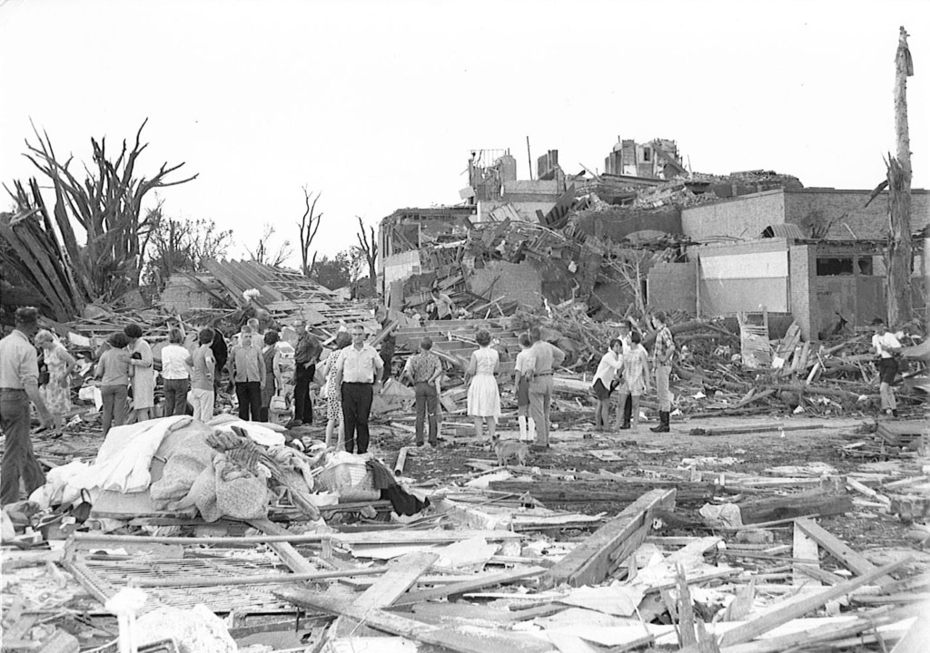
Surveying the destruction at Tracy Elementary School, which was destroyed by a June 13, 1968, F5 tornado. (Photo by The Tracy Headlight Herald and courtesy of Scott Thoma)

FOR DAYS NOW WE’VE HEARD the warnings and been advised to prepare for impending bad weather in parts of Minnesota and Wisconsin. Here’s the latest from the National Weather Service website as of early Sunday afternoon: Regardless of the risk level, an episode of dangerous weather is likely Monday, with all hazards possible…

The NWS breaks that weather threat down to include tornadoes (a few strong), large hail, damaging winds and frequent lightning. OK, then. I’m listening.

I live in southern Minnesota, which is under a “moderate” risk of severe storms. Now that word choice may not sound all that threatening until you consider that “moderate” ranks as number four on a scale of one to five. “High” risk, #5, tops the scale. Central and eastern Minnesota and western Wisconsin fall in this “moderate” risk area for severe weather.

Weather forecasters seem pretty confident in their predictions. So I have to go with what they’re saying and remain watchful and informed. And stay in contact with my friend Brad, a Minnesota native who lives in North Carolina and is retired from the NWS. He’s like my personal weather forecaster. (Thanks, Brad.)

Eric Lantz, 16, of Walnut Grove, shot this award-winning photo of the Tracy tornado as it was leaving town. He often took photos for the Walnut Grove Tribune, owned by his uncle, Everett Lantz. This image by Eric was awarded third place in the 1968 National Newspaper Association contest for best news photo. (Photo credit and copyrighted Eric Lantz)

I emailed Brad that “I really really really don’t like tornadoes,” not that anyone does. But I do have a bit of history with tornadoes stretching back to June 1968. On June 13, 1968, a violent F5 tornado with wind speeds of 261-318 mph devastated the small southwestern Minnesota town of Tracy, killed nine and injured 125. Days after that deadly twister, Dad, Mom, my siblings and I piled into the car for the 25-mile drive south of our family farm to view the destruction. The imprint of those scenes has stuck with me, which is likely the reason I respect and fear tornadoes.

More recently, in September 2018, five tornadoes (the largest an EF2) swept through my county of Rice, including in Faribault. Randy and I sheltered in our basement as strong winds raged, ripping the electrical mast from our house and downing trees throughout our neighborhood and nearby. It was frightening to be huddled in the basement, to hear that roaring wind and then to be plunged into darkness. But damage to our property was minimal. And no one was killed or injured in the county. Today I can look out my office window or walk into my backyard to see visual reminders of that severe storm in what I call “tornado trees.”

Going back further, I recall seeing the destruction in St. Peter, 40 miles to the west of my community, after a tornado touched down there on March 29, 1998. A young boy died. A childhood friend lost his home. Prior to reaching St. Peter, the tornado devastated Comfrey in southwestern Minnesota.

In 1980, a tornado took down a silo, tossed a silage wagon, ripped the railing off the house and more on my childhood farm. That was literally too close to home. It was home. I was working as a newspaper reporter some 65 miles away and raced back to Vesta the next day to see the damage. While working as a reporter in Gaylord, I also reported on and photographed damage left by a tornado.

On July 7, 2011, downbursts during severe weather heavily-damaged my childhood church, St. John’s Lutheran, and caused other damage in my hometown. In neighboring Belview, an EF1 tornado touched down on that same date causing widespread destruction. My personal weather forecaster friend, Brad, grew up in Belview.
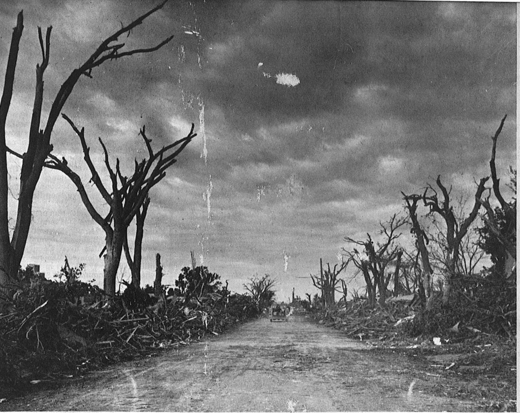
A residential street in Tracy, once covered in branches and debris, had to be plowed to allow vehicles to pass following a June 13, 1968, tornado. (Photo by The Tracy Headlight Herald and courtesy of Scott Thoma, Tracy native and author of “Out of the Blue,” a book about the Tracy tornado)

Yes, I have a history with severe storms and tornadoes. How about you?

Be alert, prepared and safe, everyone, especially my friends in Minnesota and Wisconsin.

© Copyright 2025 Audrey Kletscher Helbling


Waiting upon a predicted historic winter storm in Minnesota February 22, 2023

Blowing snow reduces visibility along Rice County Road 25/197th Street in January 2020. I expect similar or worse conditions in Rice County later today, overnight and into Thursday. (Minnesota Prairie Roots copyrighted file photo January 2020)

AS I WRITE THIS MID-MORNING Wednesday, the view outside my office window is one of a landscape layered in new snow, about five inches. The light snow of earlier has stopped.

All appears calm, until I look closer. I notice snow sweeping off my neighbor’s roof. I see, too, treetops swaying, a trio of exposed squirrel nests nestled among branches. Another neighbor’s political flags extend in the wind, bannering messages I’m weary of seeing long after the 2020 election has ended. Buffeting my front steps, dried hydrangea heads wave in the rhythm of the morning wind.

For days now, we’ve been lectured by weather forecasters and officials alike not to be lured into complacency. This lull in an anticipated historic winter storm here in Minnesota is expected. Southern Minnesota braces for storm’s second punch after overnight snow. That Minnesota Public Radio headline and similar headlines have played across media outlets for days.

I lean into believing the National Weather Service predictions about this multi-day event that could rank among our top five winter storms. It’s not only about the quantity of snow, possibly topping 21 inches, but also about the wind. As a prairie native, I understand how quickly winds of even 25 mph can create white-out blizzard conditions, making travel dangerous and impossible. Winds are expected in some places to top 50 mph. Our governor has already declared a peacetime emergency.

When my husband left for work Wednesday morning, I asked him to remain weather aware, reminding him that this storm is about the wind as much as the snow. He works as an automotive machinist in a rural location, typically a 35-minute commute. Unlike me, Randy leans into believing storm predictions are more hype than reality. Sometimes he’s right. Time will tell. Regardless, I inquired whether his phone was fully-charged and whether a sleeping bag was still in the van. It was and it was. And I asked him to text when he arrived at work and when he leaves later today. He did and I expect he will. Roads this morning were worse in sheltered areas, he reported.

By noon our winter storm warning transitions into a blizzard warning in effect for 24 hours. It’s not often my county of Rice, just south of the Twin Cities metro along Interstate 35, enters blizzard status. I expect this designation in southwestern Minnesota and other primarily open land area parts of the state, but not here.

Whatever happens, we’ve been warned by the National Weather Service, Twin Cities, on their Twitter page Wednesday: There seems to be some confusion this morning because the sun has come out. Does this mean all we got is a measly 3-5” and it’s over? Nope! As we’ve talked about for days, round 2 is on the way and it will pack a punch! Expect an ADDITIONAL 10-15” by tomorrow morning.

© Copyright 2023 Audrey Kletscher Helbling


Preparing for another major winter storm in Minnesota February 21, 2023

(Minnesota Prairie Roots copyrighted file photo 2018)

WHEN A MAJOR WINTER STORM is in the forecast for Minnesota, we Minnesotans listen intently. And then we stock up on eggs, milk and bread. Or so the joke goes. But, in reality, grocery stores do experience an uptick in business. Liquor stores, too. And for anyone who owns a snowblower—and that’s most of us—having enough gas to fuel snow removal is a must, not an option.

So here we are, poised to get massive quantities of snow over several days. Faribault is in the 17 to 22-inch snowfall range, according to the National Weather Service forecast on Monday. That bull’s eye target of snow stretches from western to eastern borders across a wide swatch of southern Minnesota from around Mankato in the south to St. Cloud in the north.

And then as if the large amounts of snow aren’t enough, winds are anticipated to rage, blowing around all that light, fluffy snow. The 40-45 mph winds gusting up to 50 mph will create white-out and blizzard conditions in many regions, especially on the prairie.

This looks to be a doozy of a winter storm that begins on Tuesday afternoon, ends on Thursday evening. Forecasters seem quite confident it will play out as predicted. I expect closures of schools, businesses and more. I expect snow gates (yes, there’s such a thing) to be pulled across interstates and other highways. There will be winter storm (our warning starts at 3 pm today) and blizzard warnings, travel advisories, “no travel recommended” and most likely stranded motorists who need rescuing.

Randy and I are prepared. I have a stack of library books to read. We have 2 ½ dozen eggs (thanks to a friend who has free-range chickens), enough milk and nearly a full loaf of bread. The snowblower gas tank is topped. And the mini fridge in the basement is stocked with craft beer. Yup, we’re ready…

© Copyright 2023 Audrey Kletscher Helbling


Bracing for a strong winter storm in Minnesota April 13, 2018

Filed under: Uncategorized — Audrey Kletscher Helbling @ 10:21 AM
Tags: , , , , , , , , ,


A GALLON OF UNOPENED milk sits on the top shelf of the refrigerator. A full loaf of bread is tucked into a kitchen drawer. We are ready. Milk. And bread. Two staples.

Randy and I joke about having milk and bread on hand whenever a major winter storm is forecast for Minnesota. And one is for today in to Saturday with blizzard warnings issued for the western part of the state and a winter storm warning for much of southern Minnesota, including the Twin Cities metro.

I’ve heard forecasts of up to a foot of snow in my area. Heavy. Wet. Preceded by rain (already falling), sleet/freezing rain and then snow. Up to an inch of snow an hour. Plus strong winds.

Already people and organizations are rescheduling events like the Echo Fire Relief Association Pork Chop Dinner, the Women’s Cannon River Conference Spring Gathering, a Redwood Senior Dining Potluck…

Saturday will be a good day to hunker down at home and stay off roads. Travel is expected to be difficult, especially on my native prairie where up to 18 inches of snow combined with winds of 40 – 50 mph will create blizzard white-out conditions. Fail to respect those weather conditions and you could find yourself in major trouble if stranded in the countryside. I expect snow gates will be lowered to keep drivers safe and off highways.

Several times in recent weeks, predicted snowfalls have not materialized. But we shouldn’t chance that the weather forecasters are crying wolf. Time will tell…

Be safe, my friends, if you live anywhere in the path of this winter storm.

© Copyright 2018 Audrey Kletscher Helbling