Minnesota Prairie Roots

Writing and photography by Audrey Kletscher Helbling

Learning about the Wahpekute in Faribault September 2, 2022

Signage marks an entry to Wapacuta Park near my Faribault home. (Minnesota Prairie Roots copyrighted photo September 2022)

FOR 38 YEARS I’VE LIVED in the same house, “the Swanson house,” along Willow Street in Faribault. Just below Wapacuta Park, blocks from the home of town founder Alexander Faribault. Wednesday evening I learned information about the park up the hill, about my neighborhood, which left me feeling unsettled and troubled, but newly-informed.

This shows just a small section of Wapacuta Park, shelter in the distance. (Minnesota Prairie Roots copyrighted photo September 2022)

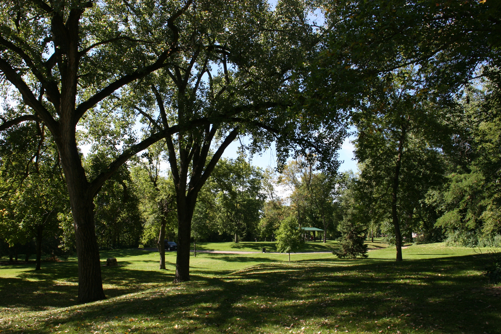
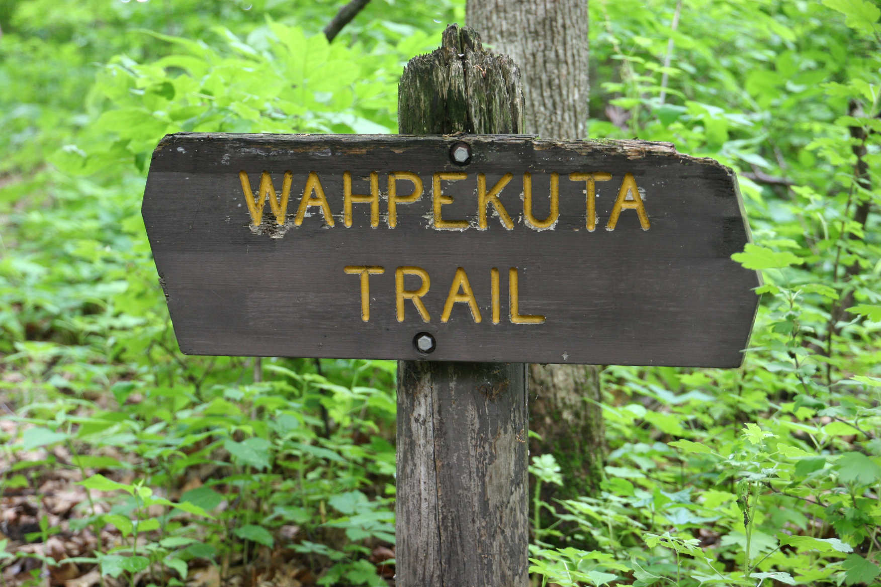
The park atop the hill, according to Susan Garwood, executive director of the Rice County Historical Society, was used by the Wahpekute, one of the seven “Council Fires” of the Dakota Nation, for honoring their dead. Not for final burial of their loved ones in this place which now houses a picnic shelter, playground, disc golf course and basketball courts, but rather for the construction of scaffolding to temporarily hold the deceased. Letters and other documents verify the placement of the scaffolding in Wapacuta (incorrectly spelled) Park.

I had no idea. No idea at all that this hilltop land held such importance in the lives, and deaths, of these Indigenous Peoples who called Rice County home long before French Canadians and others settled here.

Peace Park, where Wahpekute were buried, is located near Buckham Memorial Library in the background. (Minnesota Prairie Roots copyrighted photo September 2022)

The monument in Peace Park honors those who served in WW II. There is no mention that this slice of land is a Wahpekute burial site. (Minnesota Prairie Roots copyrighted photo September 2022)
The WW II monument at Peace Park. That’s Willow Street running aside the park. The area across the road is being cleared for apartments and senior housing. (Minnesota Prairie Roots copyrighted photo September 2022)

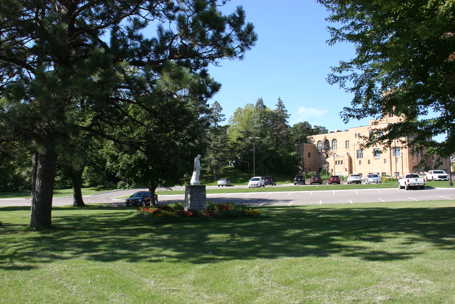
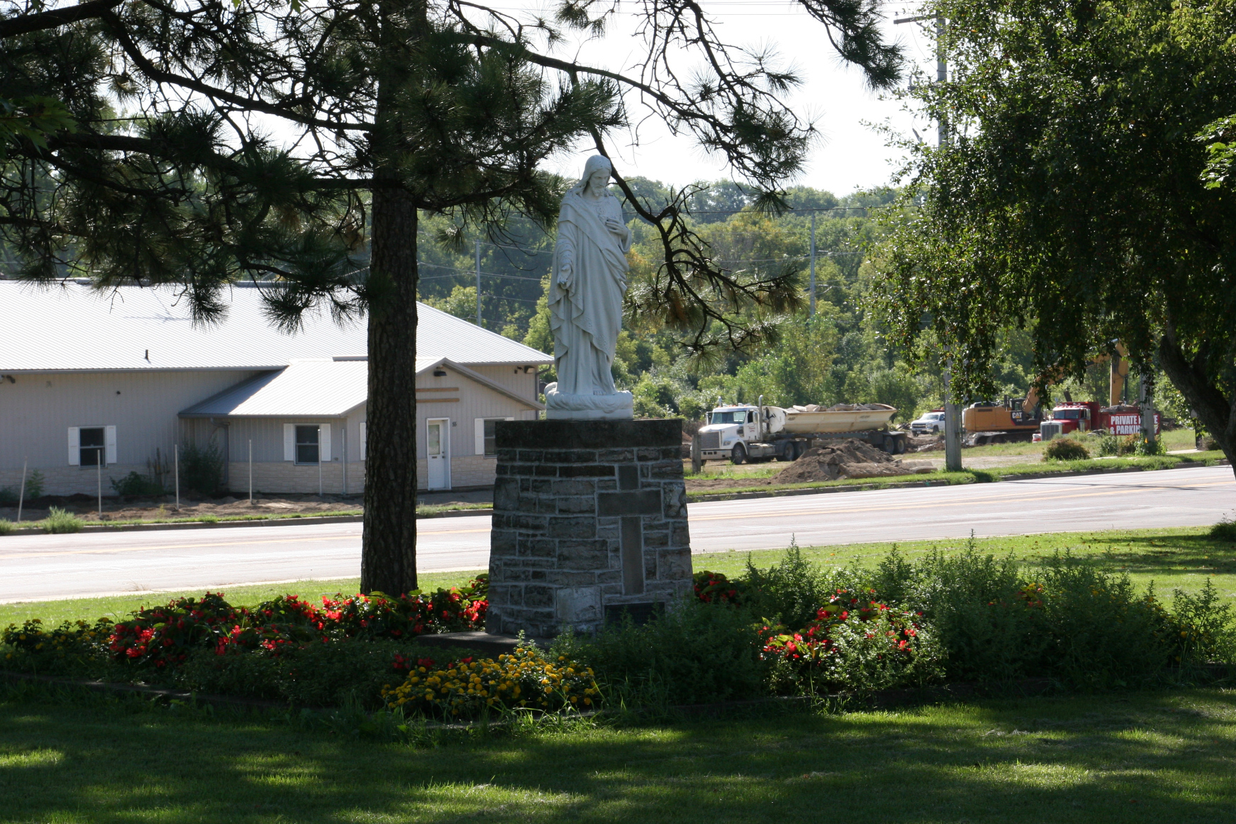
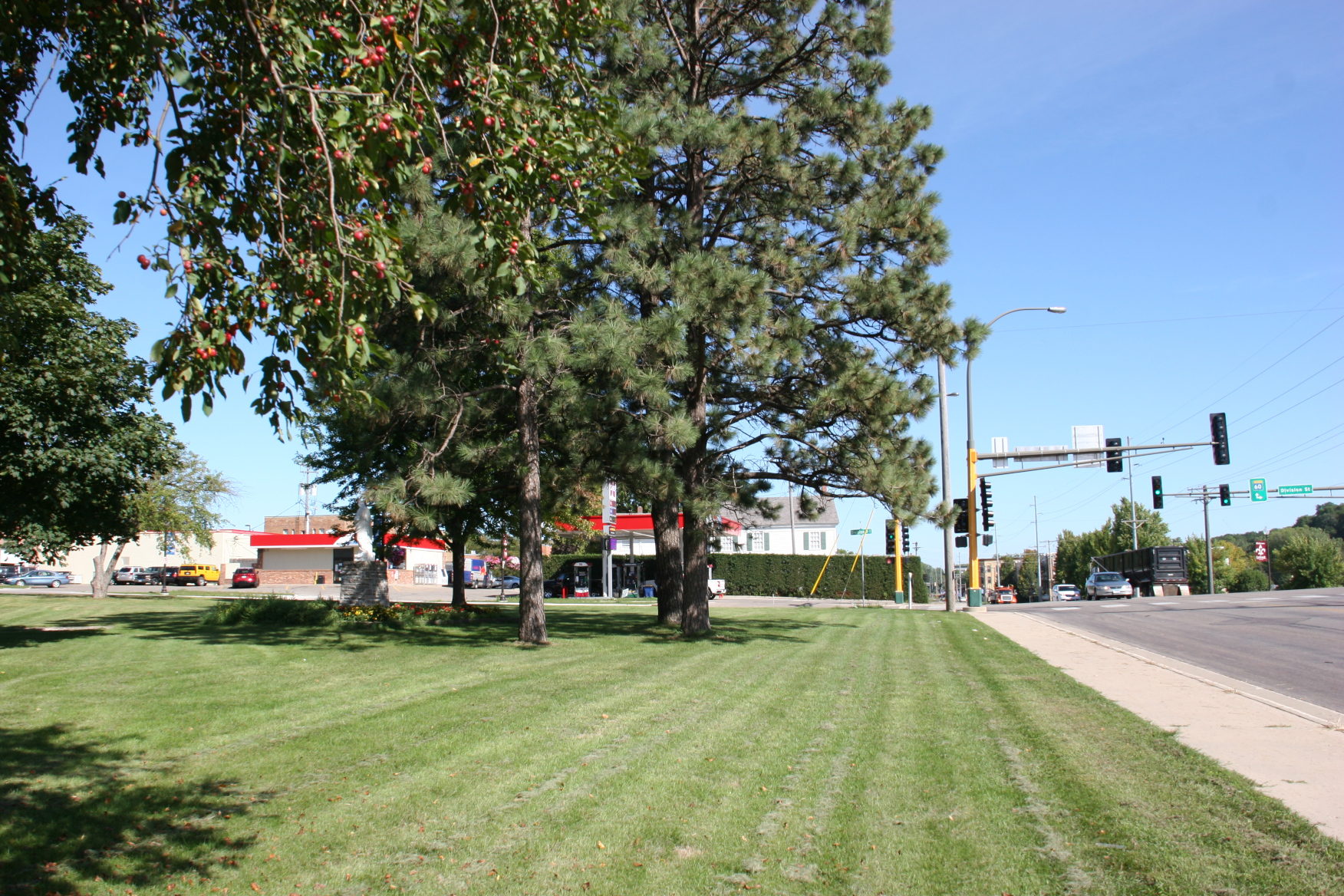
But Garwood shared even more unknown-to-me information. After a year, the bodies of the Wahpekute were removed from the scaffolding to a nearby burial spot. That’s the current day Peace Park, located near the intersection of Minnesota State Highway 60, Division Street and Willow Street by Buckham Memorial Library. The site, she said, is considered a cemetery, confirmed many decades ago by the discovery of bones wrapped in bark and hide. There were 14 burial mounds and sacred sites in the county, according to Garwood, who said this is closely-guarded information known to historians.

To learn all of this proved enlightening and left me wondering how many others are unaware. And what can be done to raise awareness and respect? Garwood asked the same question during her public presentation on “The Indigenous History of the land that is now Rice County, Minnesota.” She was the first presenter in a new endeavor, the Faribault Diversity Coalition Speaker Series, which will introduce those who call/called Faribault home through these monthly speaking events at the Paradise Center for the Arts.

This was part of an outdoor art installment at Bridge Square during Northfield’s Earth Day celebration. (Minnesota Prairie Roots copyrighted file photo April 2022)

Near the end of her hour-plus-long talk followed by questions and comments, Garwood encouraged attendees to remember and acknowledge the Wahpekute, who are still here. She referenced a Land Acknowledgment Statement and “Eagle Relatives” sculpture now in place in neighboring Northfield. She also mentioned efforts underway to honor the culture, history and places of the Wahpekute in Faribault. She encouraged all of us to become informed, to educate ourselves, to listen to the stories of Indigenous Peoples.

These first peoples lived in harmony with nature, with the land, Garwood noted. Life changed when fur traders came to the area and a dependency grew as the Wahpekute traded for goods that would make their lives easier. The US-Dakota War of 1862, centered to the west in Redwood, Renville and Brown counties, brought more change, including the loss of life, land and relocation for Indigenous Peoples. That aspect of Garwood’s talk was familiar to me given I grew up in Redwood County.

This sculpture of Alexander Faribault with a Dakota trading partner stands in Faribault’s Heritage Park near the Straight River. Faribault artist Ivan Whillock created this artwork gracing the Bea Duncan Memorial Fountain. (Minnesota Prairie Roots copyrighted file photo)

She talked, too, about Alexander Faribault and Bishop Henry Whipple and how they befriended and helped the Dakota. Faribault, after the 1862 war, offered land he owned (today River Bend Nature Center and the Minnesota State Academy for the Blind) as an “Indian Camp,” Garwood said. Sixty-five Wahpekute from 12 families lived there.

Peace Park is located at a major Faribault intersection. The Alexander Faribault house can be seen in the background, just to the right of the red-roofed gas canopies at the local co-op and behind the hedge row. (Minnesota Prairie Roots copyrighted photo September 2022)

Garwood focused primarily on the Wahpekute, the first people of Rice County, the “Shooters Among the Leaves.” They were, she said, hunters and gatherers who did not work the land but rather moved from place to place to find food, to sustain themselves. Every lake in the county was home to a Wahpekute village, she said. Rivers, too. Teepee Tonka Park along the banks of the Straight River in Faribault was among their riverside homes. Not far from Peace Park. Not far from Wapacuta Park. Near my home.

© Copyright 2022 Audrey Kletscher Helbling


Reflecting on the Wahpekute in my area of Minnesota August 4, 2022

Following the Wahpekuta Trail (albeit incorrectly spelled) at Sakatah Lake State Park, rural Waterville, Minnesota. (Minnesota Prairie Roots copyrighted photo June 2022)

IF I WAS TO CLIMB the hill behind my house through the tangle of weeds, wildflowers and woods, I would reach Wapacuta Park. But it’s easier to take the street and then the mowed hillside to this Faribault city park.

Years ago, this was the go-to spot for our family—for the kids to zoom down the towering slide and scale the massive rock in the summer and to slide down the sledding hill in the winter. Today it’s a place to occasionally take the grandkids to play on the updated playground.

My research shows this sign at Sakatah Lake State Park should be spelled differently, as Wahpehkute. (Minnesota Prairie Roots copyrighted photo June 2022)

But years ago, oh, so many years ago, this spot of land belonged to the Dakota. That I assume given its name—Wapacuta, even though incorrectly spelled. The correctly spelled Wahpekute are members of the Dakota Nation. My county of Rice is the homeland of these indigenous peoples. They are an integral part of Faribault history. Town founder and fur trader Alexander Faribault traded with the Dakota who lived in the area.

A posted map of the park. (Minnesota Prairie Roots copyrighted photo June 2022)

To the west, along Minnesota State Highway 60 between Faribault and Waterville, Sakatah Lake State Park also reflects the Dakota influence in its name. The native Dakota called the land thereon Sakatah or “singing hills” in their native language.

Native peoples sourced water directly from the Sakatah lakes, unlike here via a water pump. (Minnesota Prairie Roots copyrighted photo June 2022)

The Sakatah Singing Hills State Trail runs through the park for three miles. That trail spans 39 miles from Faribault to Mankato, another Dakota-sourced name correctly spelled Mahkato, meaning “greenish blue earth.” Mankato is the site of the largest mass execution in US history with 38 Dakota hung on December 26, 1862, after the US-Dakota War of 1862. It is a horrible atrocity in our state’s history and one which, to this day, remains unknown to too many Minnesotans.

Southern Minnesota lakes are typically polluted/green, not sky-tinted. Here the fishing pier at Sakatah State Park is inaccessible, not linked to land, due to excessive ice damage last winter. (Minnesota Prairie Roots copyrighted photo June 2022)

We are a state with many location names tracing back to the Dakota—Mankato, Wabasha, Wabasso, Sleepy Eye, Winona, Winnebago… Even the name Minnesota comes from the Dakota Mnisota, meaning “sky-tinted waters” and referencing the Minnesota River.

I saw several motorboats on the lake at Sakatah. (Minnesota Prairie Roots copyrighted photo June 2022)

On a mid-June visit to Sakatah Lake State Park, rural Waterville, I thought about the Dakota who lived on this land, including at a village on the point separating Upper Sakatah and Lower Sakatah Lakes. I imagined the Wahpekute gliding across the lakes in canoes, angling for fish in these waters.

Mushrooms cling to a tree in the woods. (Minnesota Prairie Roots copyrighted photo June 2022)

Then, as I followed the Wahpekuta Trail, I wondered about hunting and berry picking and perhaps mushroom gathering in the denseness of woods.

The Sakatah campgrounds fill quickly, like many Minnesota state parks. (Minnesota Prairie Roots copyrighted photo June 2022)

And, instead of campers in these trees, I imagined tipis.

We have much to learn as we follow the trails of history. (Minnesota Prairie Roots copyrighted photo June 2022)

I have much to learn about the Wahpekute. But at least I hold basic knowledge of their early presence here, of their importance in the history of this place I call home.

© Copyright 2022 Audrey Kletscher Helbling