Minnesota Prairie Roots

Writing and photography by Audrey Kletscher Helbling

Land eroding around Faribault Woolen Mill Dam July 3, 2024

Filed under: Uncategorized — Audrey Kletscher Helbling @ 10:21 PM
Tags: , , , , , , , ,
In this cellphone photo from the Second Avenue bridge, you can see the boulders piled across the north edge of the dam, excavator to the right. That’s the Faribault Mill to the left on the Cannon River. (Minnesota Prairie Roots copyrighted photo July 3, 2024)

WHEN I LEARNED late Wednesday afternoon of serious river bank erosion by the Faribault Woolen Mill Dam following recent flooding, one word crossed my mind—Rapidan. Last week the Blue Earth River skirted the Rapidan Dam, eroding the earth and creating a new river channel that eventually claimed buildings, trees and more.

Barricades block access to the area along the river where crews worked to stabilize the bank on Wednesday. The Faribault Mill is across the river. (Minnesota Prairie Roots copyrighted photo July 3, 2024)

Right now I don’t see that happening in my community. The dam, the river, the landscape differ. In Faribault, crews worked to mitigate further erosion by piling boulders on the north side of the mill dam. That’s a temporary fix until water levels drop and officials can check for damage to the dam.

The second dam next to Father Slevin Park is not showing serious erosion, although water is flowing over the bank on the south side. (Minnesota Prairie Roots copyrighted photo July 3, 2024)

I stopped briefly Wednesday evening to see firsthand what is happening at the two dams on the Cannon River. Water levels remain high, although lower than they have been. But more rain is predicted in the next several days. Exactly what we don’t need.

#

NOTE: I did not have my 35 mm Canon camera with me so I had to use my cellphone to shoot these photos, thus I could not zoom in to take better, clearer images.

© Copyright 2024 Audrey Kletscher Helbling


Wildlife observations from along the flooded Cannon River in Faribault June 25, 2024

An egret flies over the Cannon River by the barely visible dam at North Alexander Park on Friday evening. (Minnesota Prairie Roots copyrighted photo June 21, 2024)

WILDLIFE SENSES, understands, picks up on nuances that we as humans often fail to notice in our heads-bent-to-our-smartphones, busy scheduled lives.

A blue heron perches on the edge of a tree along the Cannon River by the park-side dam. (Minnesota Prairie Roots copyrighted photo June 21, 2024)

The recent flooding is a prime example. I saw countless cellphones raised to record floodwaters and rising rivers. I carried my 35 mm Canon camera, drawn just like everyone else to document the historic natural event unfolding before me along the Cannon River in Faribault.

An egret and blue heron seem to be checking out the river as a red-winged blackbird sits among the grasses to the right. That’s the Faribault Mill in the background, railings for the park-side dam in the foreground. (Minnesota Prairie Roots copyrighted photo June 21, 2024)

But I also noticed the wildlife. They, too, were observing. Watching the water. And watching people invade their river habitat by the hundreds. I sensed how uncomfortable the egret, blue heron, ducks and red-winged blackbirds were amid all the human chaos. So many people and so much traffic.

Flying high above the flooded river. (Minnesota Prairie Roots copyrighted photo June 21, 2024)

I expect they longed for quiet. Peace. A respite from the attention. A return to normalcy. No more peering eyes. No more crowds gathering.

A bullhead partially emerges from shallow water on dam’s edge as it tries to swim up the floodwaters. (Minnesota Prairie Roots copyrighted photo June 21, 2024)
Another bullhead attempts to swim up river. (Minnesota Prairie Roots copyrighted photo June 2021)

And then there were the fish, primarily bullheads, but a few bass, attempting to swim up through water that was rushing down, spilling over the edges of the dam by North Alexander Park. The fish appeared determined to make it to the other side, to the quieter waters of the widened river. It seemed a losing cause to me. But who am I to discourage a stubborn bullhead? If anything, it was fascinating to watch.

A duck family swims in the shallow floodwaters next to the top of the dam. (Minnesota Prairie Roots copyrighted photo June 21, 2024)

Finally, I observed a mama duck and her brood aside the top of the dam. They began edging, descending toward the river. Foolish ducks, I thought, judging the mother mallard. And then I voiced my concern out loud, “Stop, you’ll drown!”

The ducks move toward the deep river. (Minnesota Prairie Roots copyrighted photo June 21, 2024)

I can only imagine the thoughts of that mother and her six ducklings. “Did that woman really say that, warn us to stay out of the water lest we drown?” If ducks could laugh, the seven of them would have chortled, chuckled, carried on and then shared what they’d heard me say. Quack. Quack. Quackity. Quack.

A mallard drake swims in the Cannon River, nowhere near the female duck and ducklings. (Minnesota Prairie Roots copyrighted photo June 21, 2024)

But it was my husband who spoke for them. “They’re ducks, Audrey,” Randy said. “They can swim.”

An egret stands watchful and tall, next to the water rushing, roiling over the dam. (Minnesota Prairie Roots copyrighted photo June 21, 2024)

Uh, yeah. He was right. But it was the mom in me emerging, the protective spirit that, in that moment, did not separate wildlife from human so focused was I on the dangers of the swollen, swift-moving river.

© Copyright 2024 Audrey Kletscher Helbling


From city to countryside, flooding continues to affect Faribault area & beyond June 24, 2024

Roads are closed throughout the area due to flooding. Here a barricade blocks Dahle Avenue at its intersection with 220th Street East along the Straight River east of Faribault late Sunday afternoon. (Minnesota Prairie Roots copyrighted photo June 23, 2024)

NEARLY TWO DOZEN city streets, county highways and township roads remain closed throughout Rice County due to floodwaters. The number seems unprecedented. Closures include several streets in Faribault along the Cannon and Straight Rivers. More rain is possible later today. Exactly what we don’t need. However, Faribault city officials noted both rivers began to drop Monday morning.

A couple checks out flooded Dahle Avenue. (Minnesota Prairie Roots copyrighted photo June 23, 2024)

As inconvenient as these road closures may be, especially to locals, it’s nothing compared to the flooding of businesses, homes, campgrounds and more, especially in neighboring Waterville. The small town draws lake-lovers to summer cabins and campgrounds with tourism an important part of the local economy.

The muddy, fast-moving Straight River, photographed late Sunday afternoon from a bridge on 220th Street East, east of Faribault. (Minnesota Prairie Roots copyrighted photo June 23, 2024)

Other small towns, like Morristown and Warsaw, have also been impacted by the rising Cannon River. That water (and water from the Straight River) eventually ends up in Faribault and then Northfield and other places along the river and its watershed. In Faribault, public safety officials are keeping a close eye on the King Mill Dam, over which the Cannon flows. I’ve not seen that area, which is now barricaded to motor vehicle and foot traffic, and wisely so. The dam is a popular fishing spot. The road past the dam is also a busy traffic route, a connection to Minnesota State Highway 60.

Rounding 195th Street West, a flooded cornfield, photographed northwest of Faribault late Friday morning. (Minnesota Prairie Roots copyrighted photo June 21, 2024)

Out in the countryside, too much rain has drowned corn and soybean crops, turning fields into lakes. I feel for the farmers, who depend on a good crop for their livelihood. It’s too late in Minnesota’s short growing season to replant. Crop insurance will cover some of their losses.

Excessive rain flooded this cornfield, transforming it from farmland to lake. Photographed late Friday morning along 195th Street West. (Minnesota Prairie Roots copyrighted photo June 21, 2024)

Rice County has a diverse topography of flat lands and rolling hills, plus differing soil types and drainage systems. Those, and rainfall amounts, affect whether a farm field floods. The entire county has experienced substantial rains. Just last Friday afternoon and into Saturday morning, we measured 3.1 inches of rain in our gauge. The day prior, 1.75 inches. Ten inches of rain fell here in eight days. Too much.

A flooded cornfield along 195th Street West, photographed Friday morning. (Minnesota Prairie Roots copyrighted photo June 21, 2024)
Ducks swim in the cornfield turned lake late Friday morning along 195th Street West. (Minnesota Prairie Roots copyrighted photo June 21, 2024)

Ask any farmer, and he/she can likely give you rainfall totals. I saw some of that rainwater on Friday morning while on a short drive along backroads northwest of Faribault. And that was before Friday’s three-inch rainfall.

A bit down the road, more flooding in the rolling terrain along Fairbanks Avenue northwest of Faribault, photographed late Friday morning. (Minnesota Prairie Roots copyrighted photo June 21, 2024)

On Sunday afternoon, most fields in the area I traveled were not flooded, but at least one township gravel road along the Straight River was flooded and barricaded. I expect if I expanded my tour, I’d see a whole lot more road closures and flooded fields. (Click here for a list of roadways that are closed in Rice County.)

Public officials are warning people to heed warning signs (like this one on Dahle Avenue) and stay out of flooded areas due to the dangers of swift-moving, high water. (Minnesota Prairie Roots copyrighted photo June 23, 2024)

In the all of this, there’s nothing we can do to control the weather. We can only prepare and then deal with whatever comes. Those, of course, are just words, not really helpful to anyone dealing with flooded fields, flooded roads, flooded homes, flooded businesses, flooded campers, flooded parks, flooded…

© Copyright 2024 Audrey Kletscher Helbling


When torrential rains cause major flooding in my home region of southwestern Minnesota July 4, 2018

Minnesota Prairie Roots file photo.


HAPPY FOURTH OF JULY, my friends. I hope this finds you celebrating your freedom in a fun way.


The Redwood River, flooded over its banks, along Redwood County Road 10 heading south out of Vesta earlier this spring. That’s my home farm in the distance. I expect the flooding is much worse now. Minnesota Prairie Roots file photo.


In my home region of southwestern Minnesota, where I was supposed to be yesterday and today with extended family, residents are cleaning up after heavy rainfall flooded the region. Flash flooding resulted in water in basements (and higher), road wash-outs and closures, mudslides, swamped farm fields, overflowing rivers and more. That includes in my home county of Redwood. And the communities of Wabasso (where I graduated from high school) and Vesta (my hometown).

After a flurry of texts between me and my five siblings and lots of online searching yesterday, Randy and I decided not to risk the trip into the flooded region. Although I second-guessed our decision multiple times, it was the right one. This morning floodwaters flowed across a section of US highway 14 east of Lamberton, our route to and from my middle brother’s rural acreage just north of that small town. Likewise I expect the rising Cottonwood River has flooded a county road within a mile of our destination.

Some roads have collapsed in Redwood and Renville counties. I don’t trust the structural integrity of any road covered with water. The Redwood County Sheriff’s Department issued this statement on Facebook early yesterday morning:

We have had numerous (reports) of water covering the roadways. Please DO NOT drive on any roadway that has water running over it. MN DOT and Redwood County highway departments are doing the best they can do get these roads blocked off to warn motorists.


A combine similar to this was moved from a Tracy dealership onto Highway 14. Minnesota Prairie Roots file photo.


One of the most creative road blocks happened in Tracy where crews parked a massive John Deere combine across Highway 14 to keep traffic off the flooded roadway.


This road-side sculpture welcomes travelers to Wabasso. Minnesota Prairie Roots file photo.


In Wabasso, which got 11 inches of rain within 12 hours, a resident noted on social media that the white rabbit was safe from floodwaters. He was referencing an over-sized rabbit sculpture along State Highway 68. Wabasso means “white rabbit” and is the local school mascot.

It’s good to find humor in a difficult situation, in an area where residents endured another round of rain this Fourth of July morning.

To those who live in my native southwestern Minnesota (and that includes many family and friends), I am sorry you are experiencing this major flooding. Please be safe.

© Copyright 2018 Audrey Kletscher Helbling


Spring flooding in my home county of Redwood April 30, 2018

Filed under: Uncategorized — Audrey Kletscher Helbling @ 9:57 AM
Tags: , , , , , , , , , , ,

Entering my home county of Redwood along Minnesota State Highway 68 southeast of Morgan.


SEVERAL DAYS AGO, traveling back to my hometown of Vesta, I noted snow sculpted in some road ditches. This late in April, the scene was unexpected. But then a blizzard raged across southern Minnesota only weeks earlier. And that road ditch snow, hard-packed by prairie winds, had yet to melt in the then 60-degree temps.


Nearing Vesta (left in photo) along Minnesota State Highway 19, I saw more and more flooding of farm fields.


A view of the flooding from Highway 19 just northwest of Vesta.


And just across the highway, more flooding.


Beyond the snow, though, I noticed water setting in farm fields. The late significant snowfalls and plugged culverts and tiles likely contributed to the collection of snow melt water in many low-lying areas. It would be awhile, I surmised, before farmers would be working this land.


The deep blue of those temporary ponds appeals to the poet in me. I see lines of poetry in splashes of blue across an otherwise drab landscape stubbled by remnants of last year’s harvest.


The Redwood River, flooded over its banks, along Redwood County Road 10 heading south out of Vesta. That’s my home farm in the distance. There have been times when the river flooded across the roadway.


A temporary lake of floodwaters borders my hometown of Vesta.


Flooded farmland along the Redwood River on the edge of Vesta.


On the south edge of Vesta, within view of the Redwood River, a lake formed as the river overflowed its banks and flooded surrounding farm land. The town itself was in no danger with a hill—rare as they are on the prairie—bordering that end of town.


Water spreads easily across the almost tabletop flat landscape, here just north of Vesta.


There’s something about floodwaters that draws my appreciation, causes me to stand and just look at the river and recognize its power.


These grain bins sit a gravel road and short stretch of land away from the floodwaters of the Redwood River in Vesta.


I realize that soon (maybe even as I write) this flooding will be another memory as farmers ready for planting and, in several months, the harvest.


© Copyright 2018 Audrey Kletscher Helbling


A native Minnesotan reports from flooded Minot June 23, 2011

MY BROTHER-IN-LAW, Neil, lives in Minot.

But he ranks as one of the lucky residents of this North Dakota city. His house lies outside—albeit less than a mile away—and several hundred feet above the flood zone.

Yet, this Air Force man and Minnesota native isn’t sitting idly by because his home has not been threatened. He’s pitching in to help those who face the reality of losing their houses in the worst flooding since 1969.

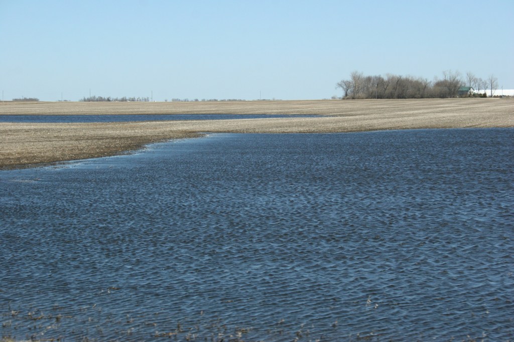
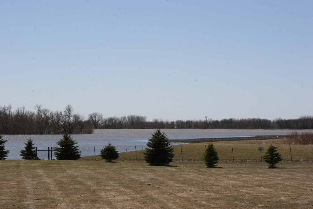
In an e-mail I received from Neil early this morning, he shares information, insights and, yes, even advice about the current situation—which he terms “exhausting and discouraging”—in his adopted hometown. The overwhelmed Souris River in Minot is expected to crest on Sunday, some five feet higher than any previous flood stage in recorded history for the area, Neil says. The old record was set in 1881, before Minot was founded.

So that’s the situation facing this city, where some 12,000 residents, more than a quarter of the population, have been evacuated and where, says Neil, dikes in several neighborhoods were breached on Wednesday.

Neil has assisted two families in exiting the city.

He writes: “I helped a lady from our church on Monday night as she moved everything either to the second floor or attic. What didn’t go upstairs went into a horse trailer that her brother brought in from out of town late that night. She seemed to take things in stride. Her house was also flooded in ’69 (before it was her house), but came through it okay. It’s extremely well built, nearly 100 years old. This lady trusts that God will provide for her needs, even if her house washes down the river.”

Neil next joined efforts to help his boss’s family. His boss is deployed to Afghanistan.

“I lost track of how many people were there to help them,” Neil writes. “We also helped them three weeks ago, when we moved everything out of their sopping wet basement to the upper floor and garage. Because of the shortage of time allowed to evacuate, we left almost everything there that time. Because of the expected height of the floodwaters and the advance preparation time, we decided to clear everything out of their house this time.”

Yet, Neil continues, “There were easily several pickup loads of stuff that we left behind simply because there wasn’t enough time/energy/resources to move it all.”

At this point my brother-in-law pauses and suggests that we all re-evaluate our possessions, deciding what we really need and what we don’t. “Go through your house and garage and get rid of anything that you haven’t laid eyes on or used in the past three years.” He intends to do exactly that at his Minot home, which is currently on the market; he’s been reassigned to an Air Force base in Missouri.

When Neil and his wife, who is already in Missouri, purchased their house several years ago, they purposely stayed away from the flood zone. “A contractor that we spoke to before buying a house told us the down sides of several locations in this town. One specific neighborhood that he told us to steer clear of is the exact one that we helped my boss’s family move out of; he told us that he wouldn’t even consider building a house down there because the whole area was under water in the flood of ’69,” Neil says.

And then my brother-in-law adds this final statement: “Dikes give people a false sense of security.  No one presently living in this town will ever doubt that again!”

© Copyright 2011 Audrey Kletscher Helbling